
he Flood Plain Lower Ringarooma River Ramsar site is located on the far north-east coast of Tasmania, between Cape Portland and Waterhouse Point. The site is situated on the sandy flood plain of the Lower Ringarooma River which encompasses extensive marshlands and a number of shallow lagoons; Shantys Lagoon, Blueys Lagoon and Bowlers Lagoon. The Ringarooma River drains out into Ringarooma Bay. The hydrology of this site is influenced by tidal flows, river flows and local groundwater. The bulk of the wetland area is above the tidal limit and is largely controlled by inflows from the Ringarooma River.
The Ramsar site is dominated by scrub and tussock grassland vegetation, and includes substantial areas of freshwater marsh habitat in the flood plain. The varieties of habitats support the following vegetation communities: Saltmarsh, Coastal grass and herbfield, Lowland Sedgy heathland, Wet heathland, Coastal heathland, Coastal scrub, Allocasuarina verticillata forest and Eucalyptus coastal forest. The Flood Plain Lower Ringarooma River is considered to be a good foraging area for dabbling ducks and other waterbirds due to the large area of shallow water. A number of bird species listed under international migratory conservation agreements have also been recorded at the site. These include: Cattle Egret, Great Egret, Latham’s Snipe, Curlew Sandpiper, Red-necked Stint, Bar-tailed Godwit, Caspian Tern and Greenshank. Australasian Shoveler, Little Tern, Hooded Plover and Fairy Tern are also known to breed within the Ramsar site. The Ramsar site also provides habitat for threatened species, including four wetland-dependent species: green and gold frog; dwarf galaxias; fairy tern; and Australian grayling. The Flood Plain Lower Ringarooma River was traditionally used by Indigenous people. It also has a history of European occupation and mining exploitation since the early 1800s. Currently, the Ramsar site is used for duck hunting and cattle grazing.
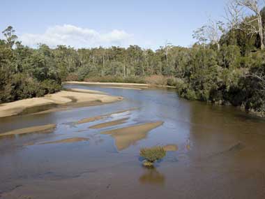
Flood Plain Lower Ringarooma River
* About the images

Government evidence of impact of climate change:
Close all
-
Australian Government, Flood Plain Lower Ringarooma River Ramsar Site, Ecological Character Description
Threats to the Site’s Ecological Character Climate change was identified as the largest threat to the site’s coastal zone.
Climate change is the main factor that possibly threatens the hydrology of the wetlands but its impacts on rainfall are not predictable with any certainty.
These include drainage of the wetland from agricultural activities (either intentionally or through stock tracks creating linear depressions that form drainage lines) loss of habitat and vegetation communities through land clearance damage to riparian condition in the Flood Plain through agricultural activities; including stock access impacts of increased sediment deposition through future land uses; including land clearance in the catchment and new mines drainage of wetland over the long term; accompanying a shift from an aggradation regime to a degradation regime in the Ringarooma River . . . declines in water quality through forestry activities upstream; including use of biocides and other chemicals (discussed above) declines in water quality through mining impacts; including spills of chemicals and discharges other than sediment introduction of weeds and pest animals through grazing on and near the site and also through on site dwellings changes in hydrologic regime through climate change changes to hydrologic regime through increased water extraction damage to habitat and vegetation communities through human access and illegal recreation activities (for example trail and quad bikes) and loss of habitat and vegetation communities through gravel extraction. . . . 4.4 Summary of the Key Threats Although there are many other potential or less major threats (see sections 4.1 to 4.3; above); Table 12 focuses on the major threats confronting the site.
Eutrophication Possible Potentially Indefinite very severe Climate Change Possible Potentially very severe Most likely impact is through rising sea levels inundating the (currently) freshwater and estuarine zones of the site.
Within the context of this ECD; the key features of climate would include extremes in natural fluctuations and also possible impacts of climate change.
climate change and is supported by data derived from nearby Eddystone Point (Figure 11).
Any sea level rise associated with climate change could allow an incursion of estuary waters into the freshwater wetland habitat; impacting on the freshwater biota within the wetlands.
Water quality is unlikely to change dramatically (beyond natural variability) unless through climate change.
The potential impacts of climate change are discussed in association with the estuary zone in Section 4.2 (below). 4.2 Threats to the Estuary Zone The key components of the estuary zone (discussed in Section 3.5.2) are the wetland habitat types (saltmarsh; intertidal mud and sand flats; estuarine waters; and coastal lagoons) the avifauna (particularly shorebirds waders and water birds); migratory and rare fish and fish and macroinvertebrates (as food).
With the exception of potential climate change impacts on delivery of rainfall; the main changes to hydrology within the Ringarooma Estuary are likely to be a result of geomorphic changes; unless water extractions increase.
A potentially major impact on the site is a possible predicted rise in sea levels accompanying global warming.
These may occur through agricultural activities other than dairying; such as stock access to streams and water bodies declines in water quality through forestry activities upstream introduction of weeds and pest animals changes in hydrologic regime through climate change and human access and illegal recreational activities (for example; trail and quad bikes). . . . value direct threat Direct stock access to riparian vegetation indirect threat strategic activity for threat reduction Damage to soil sediment structure potential monitoring point Loss of threatened vegetation communities Past mining Hydrologic changes Sedimentation Water extractions (including dams) Progression of sand slug Current mining Estuary Condition (including saltmarsh; birds; fish; macroinvertebrates and landforms) Climate change Rising sea levels Eutrophication Dairying (nutrient inputs and oxygen demand) Figure 22 Conceptual model for threats to the estuary zone of the site. .
Over a longer period of time (several decades) the cessation of sedimentation and the onset of channel degradation (that is; the sediment runs out and the Ringarooma River starts picking up the previously deposited sediment; thereby cutting its channel deeper into the Flood Plain); may be a far greater threat than the current sedimentation; with channel incision potentially causing isolation; and ultimately; a drying of the wetlands. value direct threat Current future mining Past mining indirect threat strategic activity for threat reduction Vegetation clearance potential monitoring point Sediment yield and progression Sedimentation Water extractions (including dams) Pasture improvement Damage to soil sediment structure Hydrologic changes Ecological Character (biodiversity; habitat heterogeneity; rare spp.; vegetation community types) Direct stock access to streams and wetlands Loss of threatened vegetation communities Climate change Eutrophication Weed establishment Dairy waste discharges Erosion (lowering) of stream bed Figure 23 Conceptual model for threats to the Ringarooma freshwater river; Flood Plain and wetland zone.
While the sediments are identified as potential ; there is a risk of increased acidification of the soil and of the drainage waters from these soils if any groundwater extraction or local drainage systems lead to a lowering of the groundwater table and exposure of the potential acid sulphate soils to oxidation.
Benefits and Services of the Site Although the site performs a range of benefits and services; the critical benefits and services of the site were identified as maintenance of rare and representative wetland types for the bioregion support for rare or threatened species support populations important for regional biodiversity and or at critical stages Critical Components and Processes of the Site Using SEWPAC recommended determinants; the following components and processes were identified as critical to the Flood Plain Lower Ringarooma River Ramsar Site wetland types (six identified Ramsar wetland types) regionally listed plant species (four State listed species) nationally listed bird species (fairy tern) regionally listed bird species (white bellied sea eagle and little tern) nationally listed fish species (dwarf galaxias and Australian grayling) green and gold frog nesting shorebirds (including the fairy tern) listed migratory birds (11 JAMBA CAMBA ROKAMBA CMS species) migrating fish (Australian grayling; Tasmanian mudfish and Tasmanian whitebait) . . . . . .
The key features of Figure 18 include the river within its Flood Plain; surrounded by heathland and marshes; breaking out of its channel at some points and discharging into lagoons; before reaching the estuary near the dune barrier.
The models shown in subsequent sections display the components of the systems; focusing on the key features of relevance to Ramsar listing and the environmental components that influence them. wave act on Dune Field erosion Coastal Zone Ringarooma River Saltmarsh wetland forest Sediment Inflow Marine Water Exchange Estuary Zone Freshwater Exchnage diverse estuarine ecoosystem Sand deposits Bird Diversity Salinity gradient WE WE Agriculture Irrigation Saltmarsh Community Freshwater River; Floodplain and Wetland Zone permenent Freshwater Fish Biodiversity wetland irrigated agriculture School of Fish Reproduction reed bed wetland Dairy and Cattle Grazing le Nutrient Run off We Aquatic Invertebrate Diversity Mixing proceses Freshwater crayfish Biodiverisity No No No Sediment Flux teme Aqautic Vegetation Submerged Eucalytus Forest Water Inflow Acacia Forest Melaleuca Forest oor Sediment Resuspension VIC Aqautic Vegetation Emergent Figure 18 Landscape conceptual model of the Flood Plain Lower Ringarooma River Ramsar Site. 3.6.2 Conceptual Model for the Coastal Zone Components and processes of the coastal zone that are important contributors to the site’s ecological character include the zone’s geomorphology; water quality; shorebirds and food for the shorebirds (fish and invertebrates) (Figure 19).