
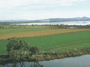
The Gippsland Lakes Ramsar site is located approximately 300 km east of Melbourne on the low-lying South East Coastal Plain bioregion. Covering a vast area, the lakes are a series of large, shallow, coastal lagoons approximately 70 km in length and 10 km wide, separated from the sea by sand dunes. The surface area of the lakes is approximately 364 km2 and the three main water bodies are Lakes Wellington, Victoria, and King. The Gippsland Lakes together form the largest navigable inland waterway in Australia, and create a distinctive regional landscape of wetlands and flat coastal plains of considerable environmental significance. The Mitchell Delta of the Ramsar site is a classic form of digitate delta and ranks as one of the finest examples of this type of landform in the world. The silt jetties of the delta extend almost eight kms into the lake as low, narrow tongues of sediment that were formerly bordered by a wide zone of reedswamp. The Ramsar site contains 11 Ramsar wetland habitat types including most notably, coastal lagoons, subtidal seagrass and algal beds, and a range of saline, brackish and freshwater marsh environments. The site supports a broad range of ecosystem services including nationally and internationally threatened wetland species, waterbird breeding and fish spawning sites. Cultural and socio-economic values are equally diverse, noting the particular importance of the site in a regional context in terms of recreational activities such as boating, recreational fishing and holiday tourism. The Gippsland Lakes support three nationally vulnerable and endangered wetland-associated flora species (dwarf kerrawang, swamp everlasting and metallic sun-orchid), and the nationally threatened growling grass frog and green and golden bell frog . The bird diversity of the Ramsar wetland is high with 86 species of waterbirds being recorded including large numbers of the red-necked stint, black swan, sharp-tailed sandpiper, chestnut teal, musk duck, fairy tern and little tern. Currently, parts of the Lakes system are heavily used for commercial and recreational fisheries and boating activities, while the immediate hinterland has been developed for agricultural use, and limited residential and tourism purposes.
Gippsland Lakes
* About the images

Government evidence of impact of climate change:
Close all
-
Australian Government, Gippsland Lakes Ramsar Site, Ecological Character Description
Contemporary threats include the prevalence and severity of recent algal blooms and the implications of climate change particularly sea level rise on the Gippsland Lakes.
Except for step climate change; deep lakes are likely to be relatively insensitive to likely changes in inflows.
As climate change occurs; the climate of Victoria is expected to become warmer; water availability will reduce and extreme storm events are likely to increase in frequency (State of Victoria 2008).
In terms of water inflows and wetlands; a significant implication of climate change will be that while there will continue to be large flow events; the frequency of flooding; flows and duration of inundation is likely to reduce. 3.7.2 Geomorphology Reasons for selection The geomorphology of the site underpins the diversity of wetlands types and waterbodies present.
Two additional threats; algal blooms and climate change have been added to the list of threats presented in DSE 2003; as more current and contemporary threats to the ecological character of the site.
Table 5 Summary of major threats to the Gippsland Lakes Ramsar site Threat Potential impacts to wetlands Likelihood of impact Timing Medium Altered water regimes Impact on water quantity and quality in downstream marshes and lagoons Short to long term Salinity Medium Catchment driven salinity caused by rising groundwater levels Long term Pollution Accumulation of nutrients (leading to algal blooms) Medium to high Short to long term Medium Pest plants and animals Reduced regeneration of native flora and predation on native fauna Short to long term Natural resource utilisation Grazing and overfishing Low Medium to long term Dredging Medium Dredging of sand from entrance channel occasional use in beach nourishment Short to medium term Activation of acid sulfate soils Reduced pH fish kills Low to medium Medium to long term Recreation and tourism Disturbance to flora and fauna litter and water pollution Medium Medium to long term Fire Medium Loss of protective vegetation cover increased stream sediment and turbidity Increased sediment and turbidity Short to long term Erosion Medium Short to long term Algal blooms Growth of phytoplankton blooms High Short to long term Climate change Sea level rise; increased rate of erosion; increased drought Medium to high Long term Timing short term 1 5 years medium term 5 10 years long term decades
It is noted that drought and high temperatures associated with climate change; combined with an expected increase in the incidence of storms; are expected to exacerbate fire risk in the region in the future.
Climate change induced sea level rise (refer discussion below) and increased intensity of tidal storm surge has the potential to significantly increase foreshore shoreline erosion and inundation processes.
Related to the discussion below on climate change; increased saline intrusion into the Gippsland Lakes system through a breach in the Boole Boole Peninsula as a result of sea level rise may have the unexpected positive impact of reducing the frequency of Nodularia algal blooms; which are sensitive to salinity but would favour more salt tolerant phytoplankton species including Synechococcus (Cook et al. 2008).
Climate change As outlined in the Gippsland Estuaries Action Plan (GCB 2006); a sea level rise of seven to centimetres is predicted across Western Port and the Western and Eastern coastal regions of Gippsland Lakes (0.8 to 8.0 centimetres decade) by 2070.
The Gippsland coast contains large areas of dunes that are vulnerable to erosion; which will be exacerbated by increases to sea level rise; more severe storm surges and high wave actions predicted under various climate change scenarios.
While attention to date in terms of climate change in the Gippsland Lakes region has focussed on sea level rise and coastal inundation; other potential climate change impacts are also relevant for the Ramsar site.
Particular issues include . increased extreme rainfall events associated with climate change given the dominant contribution to extreme water levels and water chemistry is due to elevated stream flow increased drought and higher temperature between major rainfall events leading to increased evaporation; which could expose and oxidise acid sulphate soils and exacerbate salinity in the shallow marsh environments . increased temperatures and reduced flows evaporation rates will increase fire risk; noting large scale fires followed by flooding are a significant trigger for algal blooms in the lakes THREATS TO ECOLOGICAL CHARACTER . changes in the patterns or intensity of agricultural use in catchment areas which may lead to increased water extraction requirements.
Key threats include altered water regimes; salinity; pollution; pest plants and animals; natural resource utilisation; dredging; activation of acid sulfate soils; recreation and tourism usage; fire and erosion.
Suppression of fire can also have a significant impact on the environmental values of some wetland ecosystems; by adversely affecting the diversity of flora and its dependent fauna (DSE 2003).
Heathland communities require prescribed burning to produce mosaics of different aged heaths in order to maintain species diversity.
While these reductions could be the result of factors outside of the site boundaries in terms of broader migratory waterbird usage patterns; Ecos (unpublished) asserts that trends in abundance for both declining and increasing species within the site are linked to changes in salinity (as a result of reduced freshwater catchment inflows from a combination of drought and or anthropogenic impacts; subsequent saline intrusion; and concomitant effects on aquatic flora and fauna; and fringing vegetation).
The extent to which these patterns relate to drought conditions over most of this period; anthropogenic impacts from increased abstraction of water from contributing catchments; increased salinity impacts in traditional freshwater water habitats from the long term estuarisation of the Lakes; natural variation or a combination of these factors cannot be definitively determined based on the absence of comprehensive sampling data over time.
In particular; there are more irregular freshwater flows into the Lake system (as opposed to the naturally variable wetting and drying cycle); high levels of groundwater and surface water salinity inputs from the catchments and increased incidences of algal blooms in the main lagoons (DSE 2003).
Likely responses of individual wetlands to altered environmental conditions; such as increased water permanency; increased salinity; soil acidification etc; are not well understood beyond broad generalizations.
Although the hypothesis most commonly cited to explain the loss of reed beds is an increase in salinity due to the inexorable salinisation of the Gippsland Lakes following the opening of the channel at Lakes Entrance in 1889; other reasons for the loss of common reed in the Lake Wellington region may include high salinities in Lake Wellington during drought years shallow water tables discharging saline water into the root zone limited grazing pressure.