
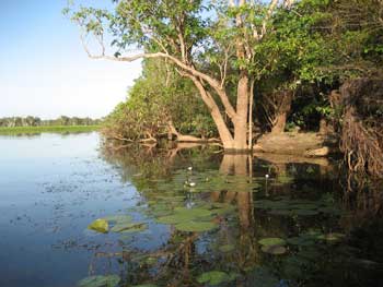
Kakadu National Park Ramsar site is located approximately 220 kilometres east of Darwin, Northern Territory. The National Park straddles the western edge of the Arnhem Land Plateau where scarp retreat and lowland erosion have formed a diverse landscape of escarpment, rocky gorges and waterfalls, broken hills, valleys and extensive floodplains. The Ramsar site is a mosaic of contiguous wetlands comprising the catchments of two large river systems, the East and South Alligator rivers, seasonal creeks and the lower reaches of the East Alligator River. It also includes the Magela Creek floodplain, the lower South Alligator floodplain, virtually the entire West Alligator River system and nearly all the Wildman River system.
Kakadu National Park comprises of sandstone plateau communities, escarpments, extensive seasonal floodplains, estuaries, tidal flats and offshore islands. The rivers are tidal in their lower reaches and are associated with extensive tidal flats formed from riverborne mud. The tidal mudflats of the rivers are largely bare of vegetation except for the inland zone where samphire, sedges and grasses are present. The vegetation of the wetlands is predominantly grass and sedge communities with freshwater mangrove or paperbark swamps along stream and lagoon edges. The Wildman, West Alligator and East Alligator rivers support bands of mangrove forest along their tidal reaches. Lilies and ferns occur in the deeper permanent lagoons. During the dry season water contracts into lagoons and billabongs and up to two million waterbirds accumulate on the floodplains. At least 53 species of waterbirds use the Ramsar site including large concentrations of magpie geese and wandering whistling-duck. These and many other species breed in the wetlands but most species are dry season migrants. Both freshwater and saltwater crocodiles are known to breed within the Ramsar site. Fifty-nine fish species are known from the wetland, including eight with narrowly restricted ranges. The area has significant cultural and heritage value. Kakadu has been home to Indigenous people for more than 50 000 years, and during that time the land and their culture have become intertwined. Kakadu National Park is jointly managed by its traditional owners and the Australian Government, through the Kakadu Board of Management and the Director of National Parks. The Ramsar site is also highly valued for its nature-based tourism and conservation activities.
Kakadu National Park
* About the images

Government evidence of impact of climate change:
Close all
-
Australian Government, Kakadu National Park Ramsar Site, Ecological Character Description
Recent or continuing threats that are notable in the context of the site that may affect future ecological character include introduction and or proliferation of exotic flora and fauna . climate change . tourism and recreational activities (including boating) . mining activities . damage to archaeological resources and rock art; and . living resource extraction.
Of these threats; future impacts from climate change in terms of increased saltwater intrusion and impacts from the continuing persistence and spread of cane toads are seen as the most likely and potentially severe.
This expansion was attributed to global environmental change phenomena such as increases in rainfall and atmospheric carbon dioxide (Banfai and Bowman 2007).
A recent example of an extreme climatic event is a tornado that swept through the National Park in March 2007; with winds of between 230 and 270 kilometres per hour that left a three kilometre path of snapped or uprooted trees and damaged caravans near the Mary River Ranger Station; and record breaking rainfall that flooded the Oenpelli and Adelaide River areasº.
It is highly likely that the frequency and severity of extreme climatic events will increase as a result of climate change (see Section 5.3 and BMT WBM 2010). o C O C O C O C IC Number of cyclones November December January February March April Figure 3 17 Total number of tropical cyclones in the Northern Territory between 1963 and 2006 by category; where C5 is the most destructive category (source Bureau of Meteorology) 3.6.2 Geology and Geomorphology 3.6.2.1 Geology Landscape features within Kakadu National Park cover over 2000 million years of geological evolutionary history (Press et al. 1995b).
Baseline annual flow values vary over time scales measured in decades; and climate change is predicted to result in further major changes.
Short to long term Climate change Increased saltwater intrusion from sea level rise Increased rates of saltwater intrusion and loss of predominant freshwater wetland areas associated loss of species diversity and habitat and associated ecological and cultural values associated with these areas.
Medium to high Medium to long term Climate change Changes to mangrove distribution from sea level rise Medium to high Medium to long term Increased proliferation of mangroves at the expense of saltmarsh and Melaleuca communities possible loss of existing mangrove communities in foreshore and lower estuary zones due to increased sea level rise and water logging associated loss of species diversity and habitat and associated ecological and cultural values associated with these areas.
Climate change Changes to fire regime Changes to rates of evaporation and increased drought conditions leading to change in wetland inundation regimes and increased risks of wetland damage from more intense fires.
Overall; the principal threats to the wetland values of the Kakadu National Park Ramsar site from climate change can be summarised as follows increased rate and extent of saltwater inundation into freshwater coastal environments due to sea level rise and storm surge events . response of mangrove communities to rising sea level; and more intensive fire regimes that eventuate due to hotter dry seasons and the resulting damage these hot fires have on monsoon forest. 5.3.
Natural processes; such as tidal inundation of floodplains and storms; may threaten archaeological sites and rock art; and climate change could amplify the effects of these impacts. 5.
In terms of future threats to ecological chara the site continues to be threatened by weeds and other exotic flora; exotic fauna; impacts from increasing visitors and recreational activities; mining activities and future threats such as climate change which is likely to exacerbate saltwater intrusion impacts already observed. .
Examples include . climate rainfall; temperature and evaporation hydrology water balance; flooding and inundation regime . geomorphology and physical processes topography; soils; sedimentation processes and erosion . energy and nutrient dynamics primary production; decomposition and carbon cycle; and . biological processes such as (a) Biological maintenance reproduction; migration; dispersal and pollination (b) Species interactions competition; predation; succession; disease and infestation. 1.4.2 Wetland Components Wetland ecosystem components are the physical; chemical and biological parts or features of a wetland.
As such; fire can have significant impacts on the landscape and is important for maintaining species and habitat diversity (Russell Smith 1995).
Fire regimes have been modified since the arrival of Europeans; and occurrences of intense late dry season fires are thought to have increased (Andersen et al. 1998; Vigilante and Bowman 2004).
Lowland savannah areas typically experience more widespread burning than plateau and floodplain areas; although burnt areas of the floodplain have significantly increased over this time period (refer Figure 3 12).
Additionally; these grasses (especially gamba grass and mission grass) increase the fuel load of fires and result in hotter burns; which can lead to the loss of tree cover (for example; NRETAS 2009). (a) Kakadu National Park (b) Plateau 0. 1. 0. 1. . 0.
Based on expert opinion; critical life cycle processes identified in column 1 (e.g. known feeding sites; roosting sites; breeding sites; etc) have either substantially diminished (in terms of frequency or extent of usage) or are otherwise no longer being supported (relative to natural variability). 9BLIMITS OF ACCEPTABLE CHANGE Fire frequency (Process 2). 1A Large change (short term) The area of wetland burnt per year within individual habitat types will not exceed maximum recorded baseline values outlined in Gill et al. (2000) more than twice over a 20 year period. 20 year measurement periods from time of ECD preparation.
Medium change (short term) Baseline values may not represent optimal fire regimes.
Changes to Fire Regimes It is generally accepted that increased frequencies and intensities of fire associated with higher temperatures; longer dry seasons and increased weed prevalence threaten the values of the Ramsar site (for example; refer Section 5.1).
Specific threats to Ramsar values from visitor and recreational activities include 10BOVERVIEW OF CURRENT AND FUTURE THREATS disturbance to fauna species; particularly waterbirds; at feeding and nesting sites or during breeding season . recreational boating activities that can damage foreshore flora; promote salt water intrusion through alterations to hydrology and foreshore vegetation; spread weeds and feral animals; disturb fauna and introduce a range of pollutants through boat sewage; boat wash and subsequent erosion; leaching of anti fouling compounds; fuel spills etc.
Weathering; vegetation growth and feral animal; termite and fire damage also threaten to damage rock art and archaeological sites; all of which may be preventable impacts.
Fire frequency escarpment and lowlands.
Ebb flood duration and velocity become increasingly asymmetric with distance from the mouth; with flood tides having shorter durations and higher peak velocities.
Channels expand or constrict driven by tidal force and rainfall patterns WATER QUALITY Fresh with increasing salinity from evaporation SEDIMENT QUALITY Flocculates readily Habitat for yellow chat Magpie geese in high numbers Channelised tidal flows Freshwater sawfish in streams S Saltpan Tidal Interface Area Floodplain (freshwater) billabongs C Levees reform during dry season C Levee banks S Regionally endemic fish species C Crocodile breeding (March to June) Freshwater becomes saline from drying and occasional tidal inundation Long neck turtles bury in mud P C C Levees impound freshwater billabongs that support a range of aquatic flora and fauna Refugia habitiat for fish and turtles P Tourism C C Critical Services Benefits S1.
For waterbirds (excluding migratory shorebirds); a consistent pattern in changes in waterbird abundance is primarily linked to the seasonality of rainfall and the annual wetting and drying cycle of tropical wetlands (Morton et al. 1990a; Bayliss and Yeomans 1990; Chatto 2006).