
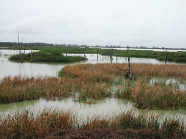
The Kerang Wetlands Ramsar site is located in northern Victoria, approximately 300 km north-west of Melbourne, on the floodplains associated with the Murray, Avoca and Loddon Rivers. The Ramsar site includes wetland types such as permanent open freshwater, deep freshwater marshes, tree-dominated wetlands, and permanent and semi-permanent saline wetlands. More than 150 species of native plants have been recorded within the Kerang Wetlands Ramsar site. A range of vegetation communities are supported by the site, including black box, river red gum, tangled lignum, chenopod shrubland, grassland and reed beds. Tangled lignum provides shelter and nesting substrate for the Australian white ibis (Threskiornis molucca) and straw-necked ibis (Threskiornis spinicollis), while cumbungi is used by the Eurasian coot (Fulica atra) and purple swamphen (Porphyrio porphyrio). Over 100 species of native fauna have been recorded, including 76 species of waterbirds. The site provides important feeding and breeding habitat for more than 50 waterbird species, many of which are protected under international migratory species agreements and treaties. Ten nationally and/or internationally listed threatened species have been recorded within the Kerang Wetlands Ramsar site: Australian painted snipe (Rostratula australis), Plains-wanderer (Pedionomus torquatus), regent honeyeater (Anthochaera phrygia), grey falcon (Falco hypoleucos), growling grass frog (Litoria raniformis), flat-headed galaxias (Galaxias rostratus), Murray cod (Maccullochella peelii), Murray hardyhead (Craterocephalus fluviatilis), and Macquarie perch (Macquaria australasica) and silver perch (Bidyanus bidyanus). In the past, the Kerang Wetlands provided a reliable source of water and a rich and diverse supply of resources including food, medicines, shelter, clothing and tools for the Traditional Owner groups, Wamba Wamba and Barapa Barapa. There are many sites of Indigenous significance in the area including mounds, scarred trees, middens, burials, hearths, surface scatters and isolated artefacts. The wetlands are currently used for a variety of purposes including irrigation supply, saline disposal, natural feature reserves and sewage treatment. The surrounding land is primarily used for agricultural industries including grazing, dairy, horticulture and cropping. Recreational activities include camping, fishing, boating and bird watching.
Kerang Wetlands
* About the images

Government evidence of impact of climate change:
Close all
-
Australian Government, Kerang Wetlands Ramsar Site, Ecological Character Description
This has resulted from a variety of causes; including historical and current activities that may change (improve or degrade) the character of the site; including levee and weir removal environmental water allocations increasing salinity presence of pest plants and animals climate change and grazing.
Threats to the ecological character of the Ramsar site A number of threats to the ecological character of the Ramsar site have been identified; including . altered watering regimes surface water and groundwater climate change changes to level and trend in surface water quality; including salinity; nutrients; acid sulfate soils; turbidity and pH loss of wetland connectivity bed and bank erosion presence of pest plants and animals surrounding land use change; particularly agriculture; grazing and urban development and unsustainable recreational activities. .
Likelihood of threat or risk Timing of threat or risk Actual or likely threat or threatening activities Presence of pest plants and animals Potential impact(s) to wetland components; processes and or services Vegetation communities; threatened flora; recreation Highly likely Immediate Immediate Immediate Immediate to medium term Altered watering regimes communities; fish species; soils; recreation Significant wetland types; vegetation Highly likely Surrounding land use Vegetation communities; water quality; Likely change threatened flora Unsustainable Vegetation communities; waterbird Moderately recreational activities populations and habitat likely Changes to level and Significant wetland types; threatened flora trend in surface water and fauna species; waterbird breeding habitat; Likely quality aquatic species; recreation Significant wetland types; hydrology; flora Climate change and fauna; waterbird breeding habitat; Likely recreation; irrigation related services Moderately Bed and bank erosion Cultural services likely Immediate to medium term Medium to long term Medium to long term 6.
For the regulated fresh supply wetlands used for irrigation; changes to storage levels; inundation and frequency could be caused by some or all of the following factors drought; climate change; changes to irrigation demand; changes in system operation and water savings projects.
Climate change also poses a threat to the drainage wetlands as higher temperatures and dryer conditions would lead to increases in evaporation rates which affect salinity and groundwater levels.
The character of regulated fresh supply wetlands not used for irrigation is threatened by climate change and the frequency of flooding and drought within the region.
The duration of inundation at drainage basins will change if modifications to the Barr Creek diversion scheme are made or if climatic ses result in prevailin ght or floodi gimes.
Changes to the inundation of unregulated wetlands are dependent upon climatic conditions (river and run off flow; precipitation) and local land use.
These sites may be susceptible to changes in inundation frequency due to climate change and the availability and demand for water.
As more water is captured in storages due to increased human demands; increased capture of rainfall through structures such as small catchment dams and climate change; the frequency of unregulated flows and spills from storages is likely to be reduced as a greater proportion of flows are captured.
CLIMATE CHANGE Significant climatic changes have the potential to change the character of the Ramsar site; specifically its hydrology and salinity (which has repercussions on vegetation and fauna communities and habitat).
Climate change is expected to impact on all aspects of the water cycle of the region reduced rainfall and hotter temperatures producing less water for rivers and storages; drier soils resulting in less run off to waterways; and more evaporation occurring from rivers; channels and storages (DSE 2009a).
The effects of climate change on the hydrology of the various wetland types were discussed above.
Here the discussion is focused on the medium to long term threat of climate changes to the components; processes and services of the Ramsar site as a whole.
With climate change there are likely to be more frequent and extended droughts; with longer dry spells and less frequent floods.
Climate change is a significant threat as it has the potential to cause the degradation and lead to the reduction or loss of the critical services and benefits of the Ramsar site.
Table 6.2 provides a summary of predicted changes to temperature and rainfall as a result of climate change in Victoria.
Summary of predicted changes to temperature and rainfall in Victoria as a result of climate change by 2070 (adapted from CSIRO2006; CSIRO and BOM 2007).
Feature Low global warming scenario Estimate of Uncertainty change 0.5 C 0.2 C High global warming scenario Estimate of Uncertainty change Annual average temperature 1.10C 0.4 C Annual average rainfall 1.5 5 3.5 11 Seasonal average rainfall Summer 0 6.5 0 15 Autumn 1.5 5 3.5 11 Winter 1.5 5 3.5 11 5 5 11 11 2.2 1.1 5 2.5 Spring Annual average potential evaporation Annual average number of hot days ( 35 C) 1 day 20 days (inland) Annual average number of cold nights ( 0 C) 1 day 10 days (inland 20 days (highlands) a The Ramsar site could potentially be affected by climate change in a number of ways; including reduced reliability of source water resulting in a reduction of the frequency and volume of water available changes in the frequency and magnitude of unregulated flows and spills from storages as more flows are captured in storage and a reduction in the duration and frequency of overbank flows during natural flooding events (DSE 2009a).
In summary; climate change has the potential to significantly alter rainfall run off and resultant stream flows on unregulated systems such as the Avoca Marshes (that rely on natural water flows to support their wetland characteristics).
The predicted impacts of these hydrological changes to the Ramsar site as a result of climate change are outlined below. .
Changes in hydrology; climate and land use may create opportunities for the establishment of non native invasive species.
Process description and driving forces Climatic processes include precipitation; temperature; evaporation and wind.
Abrupt or abnormal climatic conditions; such as above average amounts of precipitation; can alter available habitat and timing of critical life stages; particularly during reproductive seasons. 3.2.4 Physiochemical nutrients and nutrient cycling Nutrients; including nitrogen and phosphorus specifically from fertilisers; animal industries; sewage and stormwater drains are likely to affect the Ramsar site wetlands to varying degrees; although no documentation of these affects at the time of listing is available.
This has resulted from a variety of causes; including historical and current activities that may change (improve or degrade) the character of the site; including levee and weir removal environmental water allocations increasing salinity presence of pest plants and animals climate change and grazing.
Threats to the ecological character of the Ramsar site A number of threats to the ecological character of the Ramsar site have been identified; including . altered watering regimes surface water and groundwater climate change changes to level and trend in surface water quality; including salinity; nutrients; acid sulfate soils; turbidity and pH loss of wetland connectivity bed and bank erosion presence of pest plants and animals surrounding land use change; particularly agriculture; grazing and urban development and unsustainable recreational activities. .
Likelihood of threat or risk Timing of threat or risk Actual or likely threat or threatening activities Presence of pest plants and animals Potential impact(s) to wetland components; processes and or services Vegetation communities; threatened flora; recreation Highly likely Immediate Immediate Immediate Immediate to medium term Altered watering regimes communities; fish species; soils; recreation Significant wetland types; vegetation Highly likely Surrounding land use Vegetation communities; water quality; Likely change threatened flora Unsustainable Vegetation communities; waterbird Moderately recreational activities populations and habitat likely Changes to level and Significant wetland types; threatened flora trend in surface water and fauna species; waterbird breeding habitat; Likely quality aquatic species; recreation Significant wetland types; hydrology; flora Climate change and fauna; waterbird breeding habitat; Likely recreation; irrigation related services Moderately Bed and bank erosion Cultural services likely Immediate to medium term Medium to long term Medium to long term 6.
For the regulated fresh supply wetlands used for irrigation; changes to storage levels; inundation and frequency could be caused by some or all of the following factors drought; climate change; changes to irrigation demand; changes in system operation and water savings projects.
Climate change also poses a threat to the drainage wetlands as higher temperatures and dryer conditions would lead to increases in evaporation rates which affect salinity and groundwater levels.
The character of regulated fresh supply wetlands not used for irrigation is threatened by climate change and the frequency of flooding and drought within the region.
The duration of inundation at drainage basins will change if modifications to the Barr Creek diversion scheme are made or if climatic ses result in prevailin ght or floodi gimes.
Changes to the inundation of unregulated wetlands are dependent upon climatic conditions (river and run off flow; precipitation) and local land use.
These sites may be susceptible to changes in inundation frequency due to climate change and the availability and demand for water.
CLIMATE CHANGE Significant climatic changes have the potential to change the character of the Ramsar site; specifically its hydrology and salinity (which has repercussions on vegetation and fauna communities and habitat).
Climate change is expected to impact on all aspects of the water cycle of the region reduced rainfall and hotter temperatures producing less water for rivers and storages; drier soils resulting in less run off to waterways; and more evaporation occurring from rivers; channels and storages (DSE 2009a).
The effects of climate change on the hydrology of the various wetland types were discussed above.
Here the discussion is focused on the medium to long term threat of climate changes to the components; processes and services of the Ramsar site as a whole.
With climate change there are likely to be more frequent and extended droughts; with longer dry spells and less frequent floods.
Climate change is a significant threat as it has the potential to cause the degradation and lead to the reduction or loss of the critical services and benefits of the Ramsar site.
Table 6.2 provides a summary of predicted changes to temperature and rainfall as a result of climate change in Victoria.
Summary of predicted changes to temperature and rainfall in Victoria as a result of climate change by 2070 (adapted from CSIRO2006; CSIRO and BOM 2007).
Feature Low global warming scenario Estimate of Uncertainty change 0.5 C 0.2 C High global warming scenario Estimate of Uncertainty change Annual average temperature 1.10C 0.4 C Annual average rainfall 1.5 5 3.5 11 Seasonal average rainfall Summer 0 6.5 0 15 Autumn 1.5 5 3.5 11 Winter 1.5 5 3.5 11 5 5 11 11 2.2 1.1 5 2.5 Spring Annual average potential evaporation Annual average number of hot days ( 35 C) 1 day 20 days (inland) Annual average number of cold nights ( 0 C) 1 day 10 days (inland 20 days (highlands) a The Ramsar site could potentially be affected by climate change in a number of ways; including reduced reliability of source water resulting in a reduction of the frequency and volume of water available changes in the frequency and magnitude of unregulated flows and spills from storages as more flows are captured in storage and a reduction in the duration and frequency of overbank flows during natural flooding events (DSE 2009a).
In summary; climate change has the potential to significantly alter rainfall run off and resultant stream flows on unregulated systems such as the Avoca Marshes (that rely on natural water flows to support their wetland characteristics).
The predicted impacts of these hydrological changes to the Ramsar site as a result of climate change are outlined below. .
Changes in hydrology; climate and land use may create opportunities for the establishment of non native invasive species.
Abrupt or abnormal climatic conditions; such as above average amounts of precipitation; can alter available habitat and timing of critical life stages; particularly during reproductive seasons. 3.2.4 Physiochemical nutrients and nutrient cycling Nutrients; including nitrogen and phosphorus specifically from fertilisers; animal industries; sewage and stormwater drains are likely to affect the Ramsar site wetlands to varying degrees; although no documentation of these affects at the time of listing is available.
Several sites have experienced increases in salinity levels with wetting and drying cycles.
In an extreme flood event in February 2011; 12 ML of flood water was diverted to Lake Tutchewop.
These lakes were flooded in the extreme flood event of 2011.
These lakes were flooded in the extreme flood event of 2011.
The lake was flooded in the extreme flood event of 2011.
The permanent open water hydrology of the irrigation supply wetlands could be changed if irrigation operations were to be modified or if drought conditions were to result in less water availability and increases in evaporation rates.
These threats continue today with changes in inundation patterns; the frequency of wetting and drying and the volume of water available.
The character of drainage basins which receive water from flood flows or the Barr Creek diversion are susceptible to changes from frequency in inundation (similar to duration) which would result in freshening (increased frequency of inundation) or increased salinity (decreased frequency of inundation) Unregulated wetlands are largely subject to natural variability of inundation frequencies.
Rising water tables change the water regime of intermittent wetlands that are connected to groundwater sources by preventing the otherwise natural occurrence of drying out in summer (DSE 2004).
Reduction of water volumes and flood frequency may also lead to stagnation of wetlands and changes to nutrient cycling.
Decreasing the frequency of flood events is likely to impact the vegetation and habitat composition of the wetlands.
Increasing the amount of time between flood events may mean that wetlands within the system move more towards terrestrial vegetation systems.
This has also affected water quality (DSE 2004) and will continue to pose a threat to these unregulated wetlands. 6.3.3 Acid sulfate soils Acid sulfate soils are soils that contain sulphuric acid; or have the potential to form sulphuric acid when exposed to oxygen through drying or disturbance (DSE 2009).
Wetting and drying cycles have changed recently with the drought conditions in the State.
At the time of listing; this area was experiencing a period of increased flood flows (1970s to early 1990s) this period was then following by an extended drought (DSE 2010a). a Stevensons Swamp is a terminal wetland now separated from Loddon River floodwater but is otherwise largely unmodified since listing.
In an extreme flood event in February 2011; 12 ML of flood water was diverted to Lake Tutchewop.
Several sites have experienced increases in salinity levels with wetting and drying cycles.
These threats continue today with changes in inundation patterns; the frequency of wetting and drying and the volume of water available.
The character of drainage basins which receive water from flood flows or the Barr Creek diversion are susceptible to changes from frequency in inundation (similar to duration) which would result in freshening (increased frequency of inundation) or increased salinity (decreased frequency of inundation) Unregulated wetlands are largely subject to natural variability of inundation frequencies.
Rising water tables change the water regime of intermittent wetlands that are connected to groundwater sources by preventing the otherwise natural occurrence of drying out in summer (DSE 2004).
Reduction of water volumes and flood frequency may also lead to stagnation of wetlands and changes to nutrient cycling.
Decreasing the frequency of flood events is likely to impact the vegetation and habitat composition of the wetlands.
Increasing the amount of time between flood events may mean that wetlands within the system move more towards terrestrial vegetation systems.
This has also affected water quality (DSE 2004) and will continue to pose a threat to these unregulated wetlands. 6.3.3 Acid sulfate soils Acid sulfate soils are soils that contain sulphuric acid; or have the potential to form sulphuric acid when exposed to oxygen through drying or disturbance (DSE 2009).