
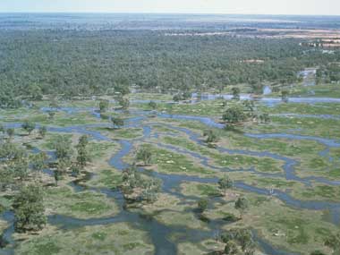
The Macquarie Marshes Ramsar site is located in central northern New South Wales, approximately 100 kilometres north of the town of Warren. The Ramsar site is comprised of the Macquarie Marshes Nature Reserve, the privately owned Wilgara wetland and the privately owned U-Block. Comprising swamps, lagoons, channels and floodplain, the area obtains water from flooding of the lower Macquarie River and its streams. Floods can occur at any time of the year and are highly variable in size and duration. Most of the wetland is semi-permanent or ephemeral, depending on the distance from the main streams and channels. The Macquarie Marshes contain a wide range of vegetation types, determined by the frequency and duration of flooding. These include River Red Gum woodland, Water Couch grasslands, extensive beds of Common Reed, Coolibah, Black Box, Lignum, reed swamp, Cumbungi and River Cooba. The range of vegetation found throughout the wetlands provides habitat for many species of waterbird, as well as a diverse array of other wildlife including 233 bird species, 29 species of native mammal, 15 frog species, 60 reptile species and 11 native fish species. Aboriginal cultural values relate to the deep history of Aboriginal interaction with the wetlands and the values, interests and aspirations of contemporary Aboriginal communities with custodial relationships to the wetlands. Aboriginal cultural values relate to specific places, specific plants and animals, and also the wetlands landscape as a whole
Macquarie Marshes
* About the images

Government evidence of impact of climate change:
Close all
-
Australian Government and NSW Office of Environment and Heritage, Macquarie Marshes Ramsar Site, Ecological Character Description
Superb parrot (EPBC Act) Threats to the Macquarie Marshes The Macquarie Marshes Nature Reserve and U block were Ramsar listed in 1986 and many of the threats that existed then are still issues in 2011 however; there are now new threats such as climate change.
It refers to any change in climate over time; whether due to natural variability or as a result of human activity. (IPCC; cited in Swart et al. 2007; p. 28) Climate change will affect rainfall; temperature and carbon dioxide levels in different ways throughout Australia.
It is estimated that changes in rainfall due to climate change will reduce stream flow in the east central MDB (which includes the Macquarie River) from 0 20 per cent by 2030 and from 5 45 per cent by 2070 (CSIRO 2008).
Other climate change factors that will affect this area are increases in atmospheric carbon dioxide (CO2) and increased temperatures.
Macquarie Marshes Ramsar Site A study undertaken on the water resources of the Macquarie River catchment; combining climate change and decadal variability; found that the most likely impacts of climate change were reductions in mean annual Burrendong dam storage; Macquarie Marsh inflows and irrigation allocations of 0 15 per cent by 2030 and 0 35 per cent by 2070.
Point sources include discharges from sewage treatment plants or industry Natural hazard Role in reducing flood water impacts (for Hydrology reduction example; reducing peak levels and Geomorphology velocity); storm protection; riverbank Wetland stabilisation and reduction in fire intensity vegetation and frequency when wet Criterion a benefit from a natural wetland Criterion 1 a benefit from a natural wetland Table 8 continues overleaf.
However; rainfall reduction and increased fire frequency may offset these increases.
The area of water couch; cumbungi and mixed marsh has also reduced to be outside the LAC set for the time of Ramsar listing; as a result of changes to the flow regime and drought conditions from 2001 to 2010.
Threats In 2012; the Ramsar site faces the same threats it did in 1986; though exacerbated by drought between 2001 and 2010.
Deep Average duration 1 6 months with a inundation greater than 60 cm maximum duration of 12 months associated with an absence of Lignum Flood timing probably spring summer Soil drying aeration between flood cycles Moist to wet soil conditions for 75 of Germination and seedling year requirements unknown; germination Floods can be shallow (5 15 cm); cannot take place under water continuous and lasting 4 6 months or Vegetative regeneration from can be flooded 2 3 times per year fragments or buried nodes may be Can recover from 1 3 year dry period important but cannot tolerate repeated dry Moist soil conditions for extended spells periods essential for both sexual and Spring summer flooding important vegetative reproduction Tolerates a range of flood Germination and seedling frequencies from permanent requirements largely unknown but inundation to infrequent flooding seed germination better in moist To maintain vigour 1 2 year flood rather than waterlogged conditions frequency required Seedlings do not tolerate flooding Flood depth probably 60 cm; Success of sexual reproduction low to a maximum depth of 200 cm Vegetative regeneration from Flood timing not critical; however fragments (stem and rhizome) likely spring summer flooding at sites with to be more important than sexual variable water levels will extend moist reproduction soil conditions and enhance growth Water couch (Paspalum distichum) Common reed (Phragmites australis) but up Macquarie Marshes Ramsar Site
Whilst spawning can occur during non flood conditions; spawning activity and recruitment success may be significantly increased during floods and higher flows.
When this source of water is less available (during periods of extended drought or when the extent of upstream diversions substantially reduces the frequency and degree of overbank flow) the trees become stressed. (Hollis et al. 2009) Macquarie Marshes Ramsar Site On ground works that increase the permanence of water bodies within the Marsh are also likely to have local impacts on groundwater.
They include . . . . . an estimated more than 50 per cent reduction in natural flows reaching the Oxley flow gauge 51 per cent of flows reached the Oxley flow gauge before river regulation compared to only 21 per cent after regulation (Kingsford Thomas 1995) a significant reduction in moderate to high flows in the Macquarie River and end of system flows (CSIRO 2008) a 114 per cent increase in the average period between large flows; which are important inundation events for the Marshes; and a reduction in the average volume of these events (CSIRO 2008) a reduction in the number of smaller flows likely to cause flooding (greater than 1000 ML day) passing the Oxley gauge following the construction of Burrendong Dam (Jenkins et al. 2007) a reduction in flood frequency; particularly of smaller size floods (Brereton et al. 2000) the imposition of permanent low flows in previously intermittent streams (Grimes 2001) a significant reduction in area inundated and frequency of floods to the Marshes (Thomas et al. 2011).