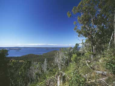
The Myall Lakes Ramsar wetland is located within the Myall Lakes National Park, approximately 75 kilometres north of Newcastle on the central coast of New South Wales. Myall Lakes National Park comprises four main lakes (the Bombah Broadwater, Boolambayte, Two Mile and Myall Lakes), together with the lesser areas of Nerong Creek, sections of the Upper and Lower Myall River, Boolambayte Creek, Fame Cove Inlet and Broughton Island. The Ramsar site incorporates a number of distinct wetlands associated with the waterways and dune systems. The waters of the Myall Lake system are shallow and of roughly uniform depth (2.4 – 3.7m) and lake level fluctuations are associated with rainfall rather than tidal influences. The main input of fresh water to the lake system is from the Myall and Crawford Rivers. The Myall Lakes comprise a series of fresh, saline and brackish water bodies of differing depths and associated vegetation types. Myall Lakes support a high plant diversity with 968 species of plants and 10 threatened ecological communites. The major vegetation communities associated with Myall Lakes are: swamp, swamp forest, wet heath, fringe forest and Lepironia swamp. Similarly, the animal species diversity is high and over 300 species have been recorded, with approximately two thirds being bird species. The wetlands regularly support large numbers of waterbirds and waders including ducks, swans, egrets and terns. In addition, Myall Lakes provide habitat for state-listed threatened species such as Masked Owl, Powerful Owl, Black-necked Stork, Wompoo Fruit-Dove, Turquoise Parrot, Little Tern, Little Bent-wing Bat, Tiger Quoll, Eastern Chestnut Mouse and Wallum Froglet. Myall Lakes National Park contains numerous middens, which are the major items of indigenous heritage. No canoe trees have been identified to date, although canoes were obviously used to reach Broughton and Little Broughton Islands. Contemporary use of the Ramsar site is mostly recreational activities such as sailing, swimming, power boating, canoeing, bush walking, four-wheel driving and bird watching. The area is also popular with commercial and recreational fishers.
Myall Lakes

Government evidence of impact of climate change:
-
Australian Government, Myall Lakes Ramsar Site, Ecological Character Description
Other main threats include climate change; fire; introduced species; and overuse or inappropriate recreational activities.
Climate change In general; climate change is expected to have a wide range of impacts on species and ecosystems; including changes in species distributions and abundances; ecosystem processes; interactions between species and various threats to biodiversity (Dunlop and Brown 2008).
The projected changes in climate and their expected biophysical responses have been modelled for the Hunter region of NSW; which includes the Myall lakes (DECC 2008 DECCW 2010c).
The expected regional climatic changes are Temperatures are almost certain to rise.
The expected impacts on land in the Hunter region of NSW resulting from climatic changes include Rising sea level is almost certain to increase coastal recession.
Climate change is likely to reduce shorebird habitat and reduce shorebird numbers.
Climate change is likely to increase stress on fragmented and degraded ecosystems and on threatened species.
In order to address the threats to biodiversity from the expected impacts of climate change; Priorities for Biodiversity Adaptation to Climate Change has been developed (DECCW 2010d).
Climate change may impact on the Ramsar site’s values as a result of sea level rise; temperature change; change in precipitation patterns and increased atmospheric carbon dioxide.
Threats Loss of habitat and changed vegetation types due to increased loads of nutrients and sediments from catchment clearing; algal blooms; disturbance by human intrusion; predation and competition by introduced species; changed lake levels from changed rainfall patterns; climate change and sea level rise.
Climate change; in particular increased temperatures and more varied rainfall; can affect many of the site’s components and processes; including the lakes’ hydrology; as a result of more intense rain and longer droughts; the fire regime in terrestrial vegetation communities; and plant and animal habitats. 8.1 Catchment land uses The periodic excessive phytoplankton growth; including toxic blue green algal blooms; shows that the system is very sensitive to increases in nutrient levels.
Inappropriate fire regimes are a significant threat to native vegetation communities; and high frequency fire is listed as a key threatening process under the TSC Act.
Vegetation communities can be altered and species eliminated if the frequency of fire is too great to enable species to maintain their life cycles.
The alteration of vegetation communities by frequent fire also has an impact on animals that depend on habitats in those vegetation communities for their survival.
Vehicle access to the Ramsar site can result in higher fire frequency as a result of arson; and in the introduction of invasive weeds and potentially harmful pathogens such as Phytophthera cinnamomi; a fungus causing root rot in eucalypts (Stephen Smith 2010; pers. comm.).
Altered fire regimes are likely to cause changes in wetter ecosystems. . . . . . . . . .
Fire can be due to natural and human activities; and in pre European times the Worimi people used intermittent fire to increase the prevalence of grasses such as blady grass (Imperata cylindrica var. major); kangaroo grass (Themeda australis); threeawn grass (Aristida vagans) and plains grass (Austrostipa aristiglumis) (Hunter and Alexander 2000).
There is little information on the relationship between fire regimes and the Ramsar site’s vegetation communities and habitats; particularly in the heath vegetation on the eastern side of the lakes where fires have been more frequent.
There is some evidence that some plants found in wet and dry heath communities; for example Banksia species; do not always establish successfully after fire by setting seed; and that Banksia seedlings require a lignotuber to have formed in order to survive a fire (Myerscough 2009).


