
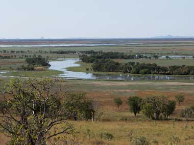
The Ord River Floodplain Ramsar site, in north-east Western Australia, is a floodplain and estuarine wetland system. Parry Lagoons, at the southern end of the site, has broad floodplains that periodically flood and dry out and permanent waterholes. North of the lagoons, the site includes the Ord River Estuary leading into the Cambridge Gulf. The north-east end of the site heads around the coast to include a series of extensive intertidal creeks and flats known as the False Mouths of the Ord. The upstream portion of the floodplain and river tends to be freshwater, and becomes more saline as the river approaches the Cambridge Gulf and falls under tidal influence. Mangroves are the most common vegetation in the site, extending from the False Mouths of the Ord to the upstream sections of the estuary. The mangroves form narrow fringes along the intertidal areas, with saltmarsh on higher ground. The intertidal mangroves support many species of birds and bats, and are a breeding area for banana prawns. The Parry Lagoon floodplains are dominated by grassland, the lower Ord River and Parry Creek by riparian woodland, and the permanent waterholes by aquatic vegetation. Over 200 species of birds have been recorded within the site including waterfowl, migratory shorebirds, mangrove birds and terrestrial species. The site supports the nationally threatened Australian painted snipe. The wetlands are habitat for many diadromous fish species (that require migration between marine and more freshwater environments some time during their life), including the nationally threatened species freshwater sawfish, green sawfish and northern river shark. Reptiles that use the site include the freshwater crocodile and saltwater crocodile. The Ord River Floodplain Ramsar site lies within the boundaries of six Indigenous language groups: Miriuwung, Gajerrong, Dulbung, Guluwaring, Djangade and Biambarr. The site contains Indigenous burial sites, artefact scatters, quarries, paintings and ceremonial sites. The Ord River Nature Reserve and Parry Lagoons Nature Reserve are gazetted for the conservation of flora and fauna. The Lower Ord River and the False Mouths of the Ord are popular destinations for locals and visitors for recreational fishing, crabbing and boating. The Parry Lagoons Nature Reserve is also important for passive recreational activities such as bird watching and bush walking. Nature based commercial tourism is an important source of income for the region.
Ord Floodplain
* About the images

Government evidence of impact of climate change:
Close all
-
Australian Government, Ord Floodplain Ramsar Site, Ecological Character Description
Category Summary Description Supporting fish populations Components and processes Climate Semi arid monsoonal 80 of rainfall in the wet season (December to February) On average evaporation exceeds rainfall in 11 of 12 months Geomorphology Estuarine reaches of river Tidal flat creek system (False Mouths of Ord) Seasonally inundated floodplain with permanent waterholes (Parry Lagoons) Hydrology Macro tidal influence Modified flows from dams upstream Low flow during dry season Higher flows in wet season Overbank flows from the Ord River to Parry Lagoons now low frequency Parry Creek major source of water for Parry Lagoons (and floodplains) Water Quality Estuary is highly turbid Potentially high nutrient levels from upstream agriculture Estuary is a net exporter of nutrients Salinity in estuary varies seasonally (30 35 ppt in dry season 4 ppt in wet) Parry Lagoons predominantly fresh Levels of agrichemicals above ANZECC guidelines detected Phytoplankton Estuary dominated by diatoms Plankton is predominantly epi benthic Vegetation Extensive mangroves in intertidal areas 15 species Saltmarsh at higher elevations Parry Lagoons characterised by extensive sedge grass lands (intermittent inundation) aquatic vegetation in permanent waterholes wooded swamp surrounding Invertebrates Commercially significant taxa include mud crabs and white banana prawns Data deficient for other communities and populations Fish 50 species (estuarine; marine and freshwater) Migratory route for approximately 17 species Supports threatened taxa listed under the EPBC Act (Freshwater Sawfish; Green Sawfish and Northern River Shark) Birds Regularly supports 20;000 waterbirds Breeding recorded for 16 species Regularly supports 1 of the population of Plumed Whistling Duck and Little Curlew Supports the EPBC listed species the Australian Painted Snipe Crocodiles Supports Saltwater and Freshwater Crocodiles The attributes that are central to maintaining the ecological character of a Ramsar site have been described as primary determinants .
The major threatening activities; the threatening processes they induce and the potential impacts to the Ord River Floodplain Ramsar site have been identified as (Figure E3) Water resource development Agricultural activities in the catchment Commercial and recreational fishing Introduced species Recreation Tidal power Fire and Climate change .
The three aspects of climate that most directly affect wetland ecology are rainfall (both local and in the catchment); temperature and relative humidity as these all fundamentally affect wetland hydrology and the water budget.
It is predicted that climate change will impact on fire regimes in Australia.
Summary of Northern Territory Climate Change Average temperatures over the Northern Territory are projected to increase by 0.2 to 2.2 C by 2030; and 0.8 to 7.2 C by 2070; relative to 1990.
Since most climate impacts are due to extreme weather events; future changes in extreme events need to be considered.
Text Box 3 Predicted climate change for the Northern Territory (Hennessy et al. 2004).
Regardless of the predicted impacts; climate change cannot be addressed at the site scale.
Late dry season fires; particularly if between fire intervals have been long; can be very intense and have significant environmental impacts including tree death; change in species composition (with a lo of fire sensitive species); los of nutrients from the soil and flow on effects to fauna from habitat and food source loss.
This may have an effect on the vegetation of tropic savannahs and forests; with a shift to communities dominated by grasses and fire tolerant trees and shrubs; at the expense of more sensitive species (Goldammer and Price 1998).
The depth; duration and frequency of flooding as well as the duration of the inter flood interval are all crucial for wetland plants (Roberts et al. 2000).
Rather; regulation of the system; which has resulted in a decrease magnitude and frequency of large floods; has resulted in accumulation of these fine sediments; that otherwise would be carried out of the system to the Indian Ocean during large flood events.