
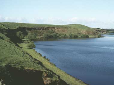
The Western District Lakes Ramsar site is located within the western volcanic plains region of Victoria, near the township of Colac. It lies within the landlocked Lake Corangamite catchment and is comprised of nine separate lakes. The lakes vary in size, depth and salinity, depending on their method of formation, catchment area and outlet. Lake Corangamite is the largest, covering approximately 25 000 hectares. The only significant river in the region, the Woady Yallock River, drains into this lake. The Ramsar site is roughly equivalent to the high-water mark of the nine lakes and vegetation within the site is therefore limited. Approximately 10-20% of the lake margins are vegetated, mostly with saltmarsh communities. A total of five submerged aquatic plant species have been recorded. Two nationally threatened species, the salt-lake tussock-grass (Poa sallacustris) and spiny peppercress (Lepidium aschersonii) occur within the Ramsar site. The Ramsar site provides habitat for approximately 70 waterbird species, 20 of which are listed under international migratory species treaties and 11 of which breed within the Ramsar site. Some species congregate there in large numbers, including the Australian shelduck, chestnut teal, Australasian shoveler, Eurasian coot and banded stilt. Six native species of fish have been recorded within the lakes of the Ramsar site. Of the invertebrates recorded, molluscs dominate most of the saline and mesosaline lakes whilst Lake Colongulac is dominated by oligochaetes. Hydrology is variable across the site. Some of the lakes are permanent whilst others are seasonal or intermittent. All are connected to saline, surficial groundwater and all except Lakes Beeac and Cundare are groundwater flow-through lakes. Most of the water is received through direct rainfall and lost via evaporation. All lakes are highly turbid and have high nutrient levels. The region is spiritually and culturally significant for the Djargurd Wurrung and Gulidjan Indigenous groups. There are several important archaeological sites in the Ramsar site, which was particularly significant for the provision of food.
Western District Lakes
* About the images

Government evidence of impact of climate change:
Close all
-
Australian Government, Western District Lakes Ramsar Site, Ecological Character Description
The most significant threat to the ecological character of the Ramsar site is climate change (EPA 2010) and this has already had a dramatic impact on the site.
Actual or likely threat or threatening activities Potential impact(s) to wetland components; processes and or services Location Likelihood’ Timing Climate change reduced rainfall Lower water levels leading to increasing salinity.
However; there is strong evidence to suggest that there have been significant changes to the ecological character of this site; primarily as a result of drought and climate change.
Moreover; there is XV evidence to suggest that other wetlands in the region (for example; Lake Purrumbete and Bullen Merri) have retained better ecological values and are expected to be more resilient to climate change (EPA 2010).
Actual or likely threat or threatening activities Potential impact(s) to wetland components; processes and or service Location Likelihood Timing Climate change drought All Certain Current Lower water levels leading to increasing salinity.
However; there is strong evidence to suggest that there have been significant changes to the ecological character of this site; driven by climate change.
The three aspects of climate that most directly affect wetland ecology are rainfall (both local and in the catchment); temperature and (to a lesser extent in temperate systems) relative humidity as these all fundamentally affect wetland hydrology and the water budget.
The most significant threat to the ecological character of the Ramsar site is climate change (EPA 2010) and this has already had a dramatic impact on the site (see Section 7).
As such threats are considered in two categories Climate Change (and associated additive and synergistic factors) and local scale threats.
Water resource development (drainage) Climate change (drought) Pollution (agricultural run off) Threat Pollution (urban wastewater) Biological resource use Invasive species Agriculture (grazing) Increased salinity Decreased water levels Increased nutrients Duck hunting Weeds (littoral zone) Physical disturbance Stressor Loss of breeding and feeding habitat Increased phytoplankton Species mortality (invertebrates; fish; vegetation) Species mortality (waterbirds) Increased competition Altered community composition Ecological effects Changed wetland type Hydrology Services Diverse wetland types Component; process; or service Waterbirds Services Physical habitat; priority wet land species Vegetation Services Threatened species Physical habitat for waterbirds Figure 42 Stressor model of the Western District Lakes Ramsar site (after Gross 2003 and Davis and Brock 2008). 5.1 Climate change Williams (1995) stated that salt lakes are more susceptible to impacts of climatic change and altered water regime than freshwater systems.
Reconstruction of climatic data and lake water levels on a couple of lakes in the region has shown that there has been an ongoing decline in levels since 1841 however anthropogenic induced climate change is likely to severely exacerbate the situation (EPA 2010).
Overall; drought and climate change have had a significant impact on the lakes of the Ramsar site; evidenced by the severe and rapid changes observed at Lake Corangamite.
The potential effects of climate change on the hydrology of the lakes within the Ramsar site has been modelled by Water Technology (2010).
For example; the modelled hydrology for Lakes Colongulac and Murdeduke with climate change (2030 scenario of lower rainfall and increased temperatures) and under current conditions illustrate the dramatic nature of predicted impacts.
However; under climate change scenarios; the reduced inflows from rainfall and overland flow; together with increased evaporation from predicted warmer temperatures; results in an increased net loss of water.
Similarly; the reduction in surface water inflows and increase in evaporation under climate change scenarios is predicted to result in a decline in water in Lake Colongulac.
Due to the strong linkages between salinity and hydrology at the lakes within the Ramsar site; impacts of climate change have and will continue to extend to altered salinity regimes.
Changes to hydrology and corresponding changes in salinity have been attributed to the persistent drought in the region (Barton et al. 2008).
Groundwater surface water interaction and the impact of a multi year drought on lakes conditions in South East Asutralia.
The 1997 2009 drought has also had notable impacts on the groundwater tables of the region (Tweed et al. 2009).
This is consistent with the findings of Tweed et al. (2009) who indicated that impacts of the drought have increased lake salinity levels by approximately 2.8 times over a nine year period to 2006 (Tweed et al. 2009).