
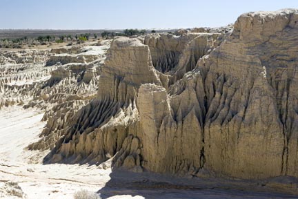
The region contains a system of Pleistocene lakes, formed over the last two million years. These lakes are now dry. Most are fringed on the eastern shore by a crescent-shaped dune, referred to as a ‘lunette’, that was formed by the prevailing winds. Today, the lake beds are flat plains vegetated by salt tolerant low bushes and grasses. Part of the World Heritage property is gazetted as the Mungo National Park, which covers about two-thirds of Lake Mungo and includes the spectacular parts of the Walls of China lunette. The remaining area comprises pastoral leasehold properties. Joulni Station at the southern end of the Mungo lunette is of cultural significance to the three Traditional Tribal Groups. There are five large, interconnected, dry lake basins and 14 smaller basins varying in area from 6 to 350 km 2. The original source for the lakes was a creek flowing from the Eastern Highlands to the Murray River. When the Willandra Billabong Creek ceased to replenish the lakes, they dried in series from south to north over a period of several thousand years, each becoming progressively more saline. The ancient shorelines are stratified into three major layers of sediments that were deposited at different stages in the lakes’ history. The lakes were full of deep, relatively fresh water for a period of 30,000 years that came to an end 19,000 years ago. The earliest sediments are more than 50,000 years old and are orange-red in colour. Above are clays, clean quartz sand and soil that were deposited along the lakes’ edges when the lakes were full. The top layer is composed largely of wind-blown clay particles heaped up on the lunettes during periods of fluctuating water levels, before the lakes finally dried up. Indigenous people have lived in the Willandra Lakes Region for at least 50,000 years. Excavations in 1968 uncovered the cremated remains of ‘Mungo Lady’ in the dunes of Lake Mungo. At 40,000 years old, this is believed to be the oldest site of ritual cremation in the world. In 1974, the ochred burial of a male Aborigine was found nearby. The skeleton, known as ‘Mungo Man’, is believed to be 40,000 years old. In 2003, nearly 460 fossilised human footprints were discovered, the largest collection of its kind in the world. The prints were made by children, adolescents and adults 19,000 to 23,000 years ago in wet clay. The clay, containing calcium carbonate, hardened like concrete, and a layer of clay and sand protected the prints. During the last Ice Age, when the lakes were full, the Mungo people camped along the lake shore, taking advantage of a wide range of food including freshwater mussels, yabbies, golden perch and Murray cod, large emus and a variety of marsupials, which probably included the now extinct giant kangaroos. They also exploited plant resources, particularly when the lakes began to dry and food was less abundant. The human history of the region is not restricted just to an ancient episode. Evidence so far points to an extraordinary continuity of occupation over long periods of time. In the top layers of sediments there is abundant evidence of occupation over the last 10,000 years. The vegetation in the region, sparse though it is, is typical of the semi-arid zone. It plays an important role in stabilising the landscape and hence maintaining its sediment strata and many species of native fauna. Small scrubby multi-stemmed mallee eucalypts are found on the dunes, with an understorey of herbs and grasses. Rosewood-belah woodland is common on the sand plains. In the lake beds, several species of saltbush are able to thrive in the saline conditions. The remains of a large number of animals have been found in the Willandra Lakes Region. More than 55 species have been identified, 40 of which are no longer found in the region, and 11 of which are extinct. Twenty-two species of mammals are currently recorded. Bats are the most diverse group, and there are some 40 species of reptiles and amphibians. The bird life of the Willandra Lakes Region is similar to that in many other semiarid areas of Australia. Parrots, cockatoos and finches are the most conspicuous of the 137 recorded species. Policy coordination and funding are joint responsibilities of the State and Commonwealth with advice from the Community Management Council, the Technical and Scientific Advisory Committee and the Elders Council. Day-to-day management is the responsibility of the New South Wales National Parks and Wildlife Service and the New South Wales Department of Lands. The Elders Council advises on Indigenous cultural matters.
Willandra Lakes Region
* About the images

Government evidence of impact of climate change:
Close all
-
Australian Government Department of Agriculture, Water and the Environment, World Heritage Places - Willandra Lakes Region
Criterion (viii) The Australian geological environment; with its low topographic relief and low energy systems; is unique in the longevity of the landscapes it preserves; and the Willandra Lakes provides an exceptional window into climatic and related environmental changes over the last 100;000 years.
-
IUCN World Heritage Outlook, Willandra Lakes Region, 2017
Evidence of past climatic change Good Trend Stable The values of the site appear to be at similar levels as at the time of inscription and remain stable (IUCN Consultation; 2017).
-
IUCN World Heritage Outlook, Willandra Lakes Region, 2020
Evidence of past climatic change Good Trend Stable The values of the site appear to be at similar levels as at the time of inscription and remain stable (IUCN Consultation; 2017).
-
Commonwealth Department of the Arts, Sport, the Environment, Tourism and Territories, Sustaining the Willandra The Willandra Lakes Region World Heritage Property Plan of Management
Salinity has been a major influence on the evolution of the landscape and the area contains an outstanding; detailed history of past episodes of salinization controlled by natural changes of climate and vegetation.
They can offer insights into human adaptations to significant long term climatic and geomorphological landscape changes.
Minimise the impact of wild fire within the World Heritage Property Strategy 12.